PUC selects route for Hampton-LaX
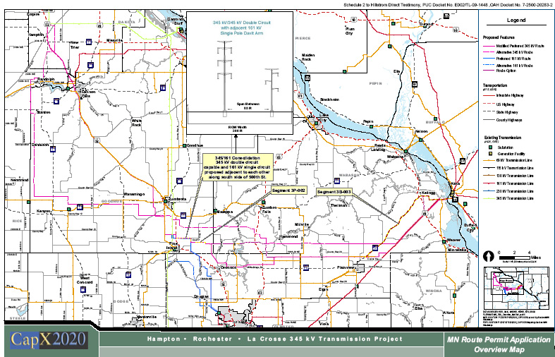
Thursday, the Minnesota Public Utilities Commission made its routing decision for the CapX 2020 Hampton-Rochester-LaCrosse transmission line. This is just a small part of the CapX 2020 Phase I lines, but it’s the last one in Minnesota, all the others have been permitted, Bemidji-Grand Rapids; Fargo-Monticello (done in two parts); Brookings-Hampton; and now Hampton-Rochester-LaCrosse:
Coming up next, as was so clear in the Wisconsin CPCN docket (hearing just completed, decision pending), is the LaCrosse-Madison line, completing the TwinCities-Madison line planned in the WIREs Phase II Report which was the subject of Testimony in the Wisconsin proceeding.
Back to Thursday…
In the Rochester Post Bulletin
And on KAAL:
KIMT in Iowa:
In the St. Paul Pioneer Press:
CapX power line route approved
Construction is expected to start in Minnesota early in 2013, and the entire project, including a route in Wisconsin, is expected to be energized in 2015, Xcel said.
Going into this decision, there were some weird things hanging that had to be dealt with.
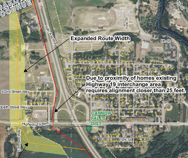
1.  CANNON FALLS: Thursday, the Commission went against the ALJ’s recommendation and took it off a segment with transmission and put it over a improperly entered segment near Hwy. 52. On the record Thursday, the Applicants admitted that their Preferred Route on Hwy. 52 was not technically feasible at the Hwy. 52 and Hwy. 19 interchange. Applicants had very late in the game inserted a “blue route” just to the west of the “Modified Preferred” route near Cannon Falls because the “Modified Preferred” route proved not feasible near the intersection of Hwy 52 and Hwy 19. There were pinch points that were not possible to mitigate due to a church and school (initially shown as a “residence” on maps) and homes sandwiched in next to the DOT easements where the DOT was also planning changes. So they made up a new route just before the hearing, and I mean JUST BEFORE the Cannon Falls hearing. The letter is dated 6/14 and the Affidavit of Service is dated 6/13 stating it was mailed 6/13… uh-huh… right. Meanwhile, this wasfiled DURING the public hearings, the week before the evidentiary hearing, I was flapping trying to reserve right for people to intervene if they wanted but realistically, there was no opportunity for any of these affected parties to participate in the evidentiary hearing, there was no opportunity to comment on environmental review because there was NO environmental review, and environmental “information” was supposedly added to the FEIS Although Xcel did attempt to call and did reach landowners, they did not call or reach ALL the landowners and apparently also missed one of the largest landowners on the southern end of this new route. State law says that actual notice is not required under Minn. Stat. 216E.03, Subd. 4:
At the time, NoCapX and U-CAN objected to this, seeing a “Myrick Road” move like in the Brookings-Hampton, when they got caught promoting a route that was clearly not feasible due to the DOT easements and so in the middle of the hearing added the “Myrick Route.” Naughty, naughty, there was no environmental review, notice didn’t go out to landowners until after the hearings, same ol’ same ol’ and it is NOT acceptable.
So going into this hearing there were two legitimate choices, the original Hwy. 52 route which admittedly is not feasible, or the Harry Avenue Route and over Byllesby dam, which were added in the Task Force process and included in the August 2010 Â CapX Hampton-LaCrosse (Alma) Scoping Decision and the DEIS and FEIS. Â Dakota County objected to the route over the Byllesby dam because of its existing Park and plans, and Jim Simon on Harry Avenue hired Rod Krass to object at the PUC meeting (and where have you been all these years, Mr. Simon?).
And the Byllesby route is the one that NoCapX said should be the route because Byllesby was the first CEO of Northern States Power. The Byllesby dam is an electrical generating dam, with a substation and transmission both north and south.  The route starts at intersection of Hwy 52 and Harry Road has transmission between 52 and the dam that is clearly visible on Google Earth and even satellite photos. Dakota County objected:
In their objection and in their testimony at the PUC meeting Thursday, they waved the Master Plan claiming that transmission was incompatible with their plans…
… but wait… READ THE MASTER PLAN! ELECTRICITY IS A BIG PART OF THE PARK!!!
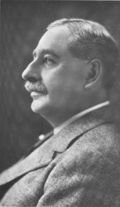
- The park is named after Henry Marison Byllesby, who designed the dam!
- The park is on land donated by Northern States Power to Dakota County (on the north) and Goodhue County (on the south).
- TWO OF FOUR INTERPRETIVE THEMES FOCUS ON ELECTRICITY (Byllesby Park Master Plan – Dakota County p. 4-18 & 4-19):
* Incorporate interpretive themes into the outdoor education programming of the park reserve:
The cultural research documented in this chapter identifies several important and interesting elements of pre-contact and historic archaeological findings. The interpretive themes resulting from research include:
o THEME 3: POWERING MINNESOTA – HENRY BYLLESBY AND THE LAKE
BYLLESBY DAM. With the increase in the population of Randolph and the subsequent move into the electrical age came the need for power in the homes, businesses, and industries of the Lake Byllesby area. The response to this need was provided by Henry Byllesby, a forerunner in the use of hydroelectric power in America. Byllesby, whose company, Consumers Power Company, was based in Chicago, realized that in directing the power of the rivers of Minnesota, North Dakota, South Dakota, and Wisconsin, he could create the energy needed to sustain the ever-growing populations of these states. One of these rivers was the Cannon River, upon which he had the Ambursen Hydraulic Construction Company construct the Lake Byllesby Dam in 1910. Six years later, he changed the name of his company to Northern States Power Company, recognized today as one of the major providers of power in the midwestern United States.o THEME 4: THE POWER OF ATTRACTION – LAKE BYLLESBY REGIONAL PARK.
Though for many years, hydropower was the most economical method of producing power, by the 1960s, larger companies had largely replaced their hydropower plants with coal or nuclear power plants. In replacing many of their hydropower facilities, Northern States Power Company opted to donate much of its property upon which these facilities were situated to the towns or counties encompassing such property. One of these properties was the location of the Lake Byllesby Dam. After the land was donated to Dakota and Goodhue Counties in 1969, Dakota County created Lake Byllesby Regional Park from potions of the land on the north shore of the lake. Lake Byllesby Park attracted residents and visitors alike to picnic, camp, fish, swim, canoe, and simply enjoy the view. Today, both the park and the dam interact to provide a sense of all facets of the area’s history, from natural history, to the history of everyday human interactions, to the engineering history at Lake Byllesby Regional Park.
Ain’t that a hoot!
Here’s the map of the last-minute addition:
Here’s the Affidavit of Service and packet – two were filed, same packet, different eFiling numbers:
This was part of Exhibit 36, similar to above, which included a cover letter and “explanation” and the maps and the notice sent to landowners:
When this late addition was being discussed at the Cannon Falls Public Hearing back last June, with several landowners present who did get notice that day or the day before, or maybe it was during the evidentiary hearing… someone from Commerce requested that the Applicants provide “environmental information” as a “late exhibit” to be included in the EIS, and I’ve just gotten a headache scanning the EIS and cannot find anything. Anyone know anything about that??? I sure can’t find it. That means another trip to Zumbrota to go through the Hearing transcript.
There are rules and laws and cases about how to route transmission. In considering a transmission route, the PUC must route using existing transmission and/or highway corridor.  If they don’t, they have to have specific findings about why they didn’t! Whatever will they say?  There is existing transmission along Harry Ave., across the dam, and south, listed in the FoF, and FOF 301 says there are THREE transmission lines on Harry Avenue!
FOF 301. Route alternatives 1P-001, 1P-002, and 1P-003 would run along existing
69 kV, 115 kV, and 161 kV transmission lines on Harry Avenue to the Cannon Falls
substation located near the hydroelectric dam that creates the Lake Byllesby Reservoir.FOF 306. There are, however, significant problems following US 52 through the
Cannon Falls area in the vicinity of Highways 19 and 24, because of the proximity of
homes, churches, schools, and businesses. Use of option 1P-003 would bypass this
area and would impact fewer total residences; would avoid the church, school, and
businesses; would parallel existing transmission lines and use mostly existing road
corridors; and would provide the opportunity to avoid potential conflicts with two future
road projects (the railroad overpass and the County Road 24 interchange).373
Not only that, there are ERRORS in the FEIS (see FEIS Map 8.1-26, p. 103).
- The transmission lines along Harry Avenue are not shown on the Route Descriptions for 1P-001, 1P-002 and 1P-003 FEIS p. 74-76.
- The transmission line apparently from the dam south to Hwy. 19 is shown on the description for 1P-002, but not along Hwy. 19 east towards Cannon Falls nor is the transmission line shown running northward from the dam to the intersection of Harry Road and 52. FEIS p. 75.
It isn’t until after you get south of Hwy. 19 that there is none. And for sure there is no existing corridor on the blue “alternate” or “bypass” route by Hwy. 52.
Explain to me how it is that the new and late route skirting around development, going through fields, next to houses is justifiable under Minnesota routing criteria and the policy of non-proliferation?!?!?
And the bottom line — despite all this, the Commission inexplicably authorized that route addition. H-E-L-L-O! The PUC cannot utilize routes that were not part of the Scoping Decision and which have not been included in the FEIS. This last-minute flailing effort to prop up the Preferred Route through Cannon Falls is NOT a route that can stand up to scrutiny. Whatever are they thinking…
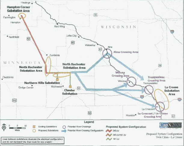
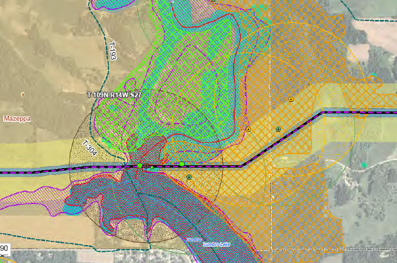
2.  ZUMBRO RIVER CROSSING: Thursday, the PUC took it off of the “Dam Route” which has no existing corridor on the east side, and put it along the “White Bridge Road” route which does — this was the only Zumbro River Crossing that complied with MN routing criteria and non-proliferation policy. Applicants had four river crossings proposed in the Certificate of Need, with the only option from the North (of) Rochester substation going east in Olmsted County. When they eliminated all the river crossings but Alma, they then added Zumbro crossings north of the original crossing (click on maps to enlarge), gong from this:
To this:
Looking at the full record, the maps, our position in this is that the ALJ may have confused the multiple Zumbro River dam and river crossings and infrastructure at each. The Findings of Fact regarding infrastructure at the Zumbro Dam crossing are contrary to the record. If you look at that map above, you can see that in Segment three, all alternatives cross the Zumbro, at the proposed “North Route,” the “Dam Route” and the “White Bridge Road” route. The second crossing is way over to the east, where both the Preferred and Alternate cross the Zumbro where Dairyland’s Q-3 line crosses.  ALJ Sheehy’s Recommendation The ALJ did note that speifically:
Given that it is crossed twice, and that we thought the judge had confused the two crossings, we filed the exception to FoF 464 because it is not factually correct. That Finding states:
Fn. 548Â Â Ex. 113, FEIS, at 174, 176.
Fn. 549Â Â Ex. 113, FEIS, at 60.
How is it wrong? Well, first, there is no “aerial crossing†of the Zumbro River at the Zumbro Dam.
The Zumbro Dam Route Option crosses the Zumbro River in a location without existing aerial infrastructure and where impacts to a high quality Maple Basswood forest (Maple Basswood) would occur on the east bank of the river     Application, p. 8-55; see also Google Earth files.
Second, there is no transmission line crossing the river at the Dam. Applicants also clearly stated that in their application.
Because both the Route Option and the Preferred White Bridge Road Route would require some tree clearing in an area characterized by residential and recreational land use, and no existing transmission line crosses the river at these locations, impacts to aesthetics would be similar for both routes.  Application, p. 8-53; see also Ex. 35, Google Earth files.
But wait — it gets worse! The DEIS incorrectly stated that there is an existing transmission line at 3P-Zumbro-N and 3P-Zumbro-S. It was something that the Applicants brought up, and a correction was requested by Applicant in DEIS Comment (p. 17, Applicant’s DEIS Comments, 4/29/11):
Zumbro River Crossings
The DEIS, at page 171, states that routes 3P-Zumbro-N and 3P-Zumbro-S cross the Zumbro River where there is an existing transmission line crossing. This statement should be corrected to note that there are no existing electrical facilities present at any of the crossings. The north Zumbro River crossing (Alternate Route) crosses the Zumbro River at a location where there is no existing infrastructure. The middle Zumbro River crossing (3P-Zumbro-N and 3P-Zumbro-S) crosses the Zumbro River at an existing dam. The south Zumbro River crossing crosses the Zumbro River at the White Bridge Road bridge.
This is referenced in the FEIS p. O-207-209Â Â Commerce response to Comment 87L:
Revised text in Recreational Resources, Section 8.3.4.12 states: No existing electrical facilities are present at any of the crossings.
Sure, Commerce corrected that one reference, however, other incorrect language referencing existing transmission crossing is found in the FEIS, on the pages which the ALJ cited in FoF 464.
p. 174:   Zumbro Dam Crossing Option – Route alternatives 3P-Zumbro-North and 3P-Zumbro-South would follow the existing crossing of the Zumbro River at the Zumbro Dam and Hydroelectric Generation Facility.
p. 176:Â Â Â Route alternatives 3P-Zumbro-N and 3P-Zumbro-S could minimize impacts to the Zumbro River because an existing HVTL already crosses the Zumbro River at this location.
Seems that the ALJ relied on these incorrect statements in her selection of the Zumbro Dam crossing, and the record does not support these findings.
To be clear, there is a low voltage line extending west from the dam, west and only west, and LOW VOLTAGE, not a high-voltage transmission line as defined by the PPSA. Applicant’s Tom Hillstrom characterized this as a distribution line at the Pine Island public hearing:
MR. HILLSTROM: Your Honor, if I may, I could add some background into that route. This was a route that was introduced during scoping, it’s 3P-009, and the route does follow an existing power line. It’s not a 69 kV line, it’s a 38.5 kV line. And while it may function as a transmission line, it’s a very old line that connects up to the hydro plant at the dam. The scale of the line is not one of a transmission line, it is basically a distribution line.
Tr. Pine Island June 15, 2011 6:30, p. 56, l. 16.
This 38.5 kV line, called a 34.5 Thursday, extends from the west edge of the dam, heading west. It does not cross the dam, and it is not a transmission line in the meaning of Minnesota’s policy of non-proliferation.
As verified in the maps at the beginning of 8.3 reviewing Segment 3 and on Google Earth:
•   p. 155 of FEIS is consistent with Tom Hillstrom’s DEIS Comment that there is no transmission at the Dam Route.
In light of these facts, then other Findings, on which the ALJ’s Recommendation are based, are incorrect. Check out FoF 436:
fn. 521 FEIS at 174.    fn. 522 FEIS at 176.
FOF 488. 3P-Zumbro-S is shorter and more direct, and it is the least expensive
option. It would impact slightly fewer residences (24 homes, versus 26 on 3P). It would follow an existing transmission line at the dam crossing, and it would not involve a crossing of Lake Zumbro. The 3P-004 option would not make the route longer but would minimize impacts to a farm in the area where the line turns north.
Judge Sheehy may have confused statements regarding infrastructure present at the Zumbro Dam river crossing with the eastern crossing of the Zumbro where there is Dairyland’s Q-3 transmission line present. Whatever the reason, she was way off base in recommending the Dam route.
This is the FEIS map of the dam route, specifically reviewed by the Commission:
Whatever their reason for not including information in the Findings of Facts, in the Environmental Impact Statement, the facts in the record, when considered under the Minnesota routing criteria and the policy of non-proliferation, do not support routing transmission over the Dam Route, leaving only the White Bridge Road as a feasible option.
And btw, people had suggested running down Hwy. 52 to Interstate 90 and east and crossing the Mississippi along the I-90 corridor, it WAS suggested, and Commerce, signed by then Grand Poo-Bah Bill Glahn, blew that option out of the water:
Gee, thanks…
And they did not deal with the Chester line in any way… what’s that about?



Comments
PUC selects route for Hampton-LaX — No Comments
HTML tags allowed in your comment: <a href="" title=""> <abbr title=""> <acronym title=""> <b> <blockquote cite=""> <cite> <code> <del datetime=""> <em> <i> <q cite=""> <s> <strike> <strong>