DEIS Meetings for ITC Midwest’s MN/IA line
This week we have three days of DEIS meetings, that’s Draft Environmental Impact Statement for the uninitiated. The schedule:
Fairmont Tuesday, April 22, 2014 1:00 p.m. and 6:00 p.m. Knights of Columbus Hall 920 East 10th Street Fairmont, MN 56031 Â Jackson Wednesday, April 23, 2014 1:00 p.m. and 6:00 p.m. National Guard Armory 108 County Road 51 Jackson, MN 56143 Â Blue Earth Thursday, April 24, 2014 1:00 p.m. and 6:00 p.m. Hamilton Hall 209 South Main Street Blue Earth, MN 56013
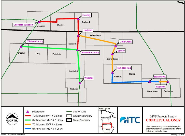
This project is important because, well, look at the red line in the map above that represents this project. It connects on the west to the Split Rock-Lakefield Jct. line from a decade ago, and then goes east, and drops down into Iowa, to become part of a web headed toward Chicago. The red and green on that map constitute MISO designated MVP3, and to the east, the orange and blue are MVP 4, and further to the east, 1/2 of which is Badger Coulee, is MVP 5. Important to note that there are 17 MVP projects, and all 17 must be built to offer the benefits touted, the modeling included all 17. Not only that, but cost apportionment also included costs to states beyond just the percentage of the one project under review, i.e., there are claims of benefits of MVP 3, but those benefits require MVP 4 and MVP 5, and in fact, ALL the 17 MVP projects. Costs to Minnesota ratepayers are “just” a portion of MVP 3, but there are also costs to Minnesota of MVP 4, MVP 5, and I think ALL of the 17 MVP projects. So the benefits that are reliant on all the 17 projects being built must be balanced against the costs attributable to Minnesota for all 17 projects! See, that wasn’t so hard, was it!
Here’s the DEIS from the Commerce ITC MN/IA DEIS page, it’s easier to cut and paste, though it’s a good idea to download because you never know when links will be changed or disappear:
Draft Environmental Impact Statement Text
- Abstract
- Table of Contents
- Summary
- Section 1 – Introduction
- Section 2 – Regulatory Framework
- Section 3 – Overview of Project and Alternative Routes and Sites
- Section 4 – Alternatives to the Proposed Project
- Section 5 – Affected Environment, Potential Impacts and Mitigation Measures
- Section 6 – Impacts and Mitigation Measures for Specific Regions / Segments
- Part 1 – Lakefield to Huntley Segment
- Part 2 – Resource Maps (9.2 MB)
- Part 3 – Resource Maps (7.3 MB)
- Part 4 – Resource Maps (8.3 MB)
- Part 5 – Huntley to Iowa Border Segment
- Part 6 – Resource Maps (6.2 MB)
- Part 1 – Lakefield to Huntley Segment
- Section 7 – Relative Merits of Routing Options
- Section 8 – References
Appendices
- Appendix A – Scoping Decision (5.7 MB)
- Appendix B – Generic Route Permit Template and Example Route Permit
- Appendix C – Transmission Line Structures
- Appendix D – Photo Simulations
- Appendix E – Example Agricultural Impact Mitigation Plan
- Appendix F – Noise Supplement
- Appendix G – Property Values Supplement
- Appendix H – EMF Supplement
- Appendix I – Archaeological and Historic Resources Data
- Appendix J – Route Analysis Data Tables
- Appendix K – Rare Resources and Rare Species
- Appendix L – Map Book
- Overview Map
- Part 1, Map Sheets LH1 to LH19 (7.3 MB)
- Part 2, Map Sheets LH20 to LH44 (8.6 MB)
- Part 3, Map Sheets LH45 to LH57; HI1 to HI12 (7.7 MB)


Comments
DEIS Meetings for ITC Midwest’s MN/IA line — No Comments
HTML tags allowed in your comment: <a href="" title=""> <abbr title=""> <acronym title=""> <b> <blockquote cite=""> <cite> <code> <del datetime=""> <em> <i> <q cite=""> <s> <strike> <strong>